LandPKS Learning
Knowledge Hub

Taking the Guesswork Out of Soil Identification
Determining land potential begins with developing an understanding of the soil. This typically requires digging a hole and measuring a soil’s physical, chemical, and/or biological properties.
Land Potential and Soil Variability
Determining land potential begins with developing an understanding of the soil. This typically requires digging a hole and measuring a soil’s physical, chemical, and/or biological properties either directly in the field or later in a laboratory. Characterizing a soil’s properties can be a challenging task, even for many soil scientists. This is due to the tremendous variability of soils across a landscape.
Soil variability is often minimized by grouping soils into classes based on similar values for important soil properties (e.g., texture). Soil classes serve as information carriers, providing valuable insight into a soil’s potential based on the documented range of soil properties values for that class. For example, if a farmer knows that the soil in their field belongs to class A, which is characterized by silty clay soils that are prone to compaction when wet, the farmer would know they need to delay spring tillage operations after a heavy rain.
Soil classes also provide information on the soil that is not easily determined in the field, such as the soil’s nutrient status (e.g., available P and N, cation-exchange-capacity, etc.), allowing land managers to modify their management practices based on known limitations associated with their soil.
The Role of Soil Map Units (SMUs) in Determining Soil Class
Knowing which class your soil belongs to is an important first step in determining how you should manage your land. But figuring out the correct soil class is difficult and without proper knowledge and training often involves a certain amount of guesswork. A main source of uncertainty arises from the fact that current soil maps do not display the exact location of soil classes. Instead most soil maps display soil map units (SMUs) which are distinct areas of a landscape that are comprised of one or more soil classes.
For example, Figure 1. shows a soil map displaying the delineated areas for different SMUs. The ‘Tc’ SMU has five soil components (or classes) associated with it. While most soil maps list the areal percentage for each component within the SMU (e.g., Component 1= 50% of the SMU area), they do not show their exact location. Consequently, the soil component at the plot location marked by the red dot in Figure 1 could be any one of the five listed soil components.

Figure 1. Example area of a soil map illustrating the delineation of soil map units (SMUs). The ‘Tc’ SMU has five soil components within it. Since the exact location of the soil components is unknown, the actual soil type at the plot location marked by the red dot could be any one of the listed five.
How to Use LandPKS to Get a Better Soil Class Prediction
To address the challenges associated with identifying your soil, the LandPKS SoilID has implemented a new tool called SoilID that assists users with correctly identifying their soil component. To get a better prediction of your soil, follow these three easy steps. SoilID is implemented in three simple steps. Figure 2:
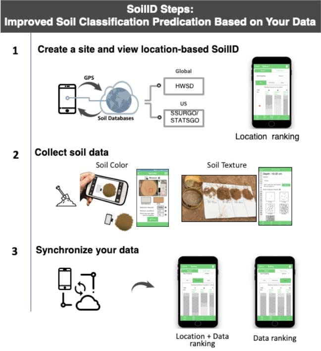
1. Create a site and view location-based SoilID
The first step occurs automatically whenever a new LandPKS plot is created (Figure 2, top). Using the phone’s GPS location, SoilID searches for all mapped soil components surrounding your location and retrieves all available soil property data. Using the location information associated with each soil component (i.e., map unit distance and component aerial percentage), SoilID provides an initial ranking of the most likely soil components at your location (i.e., ‘GPS’ ranking).
2. Collect Soil Data
The second step (Figure 2, middle) requires you to measure and record soil property information using LandPKS’s LandInfo module. Here is an introduction to the LandPKS LandInfo module. The LandInfo module guides users in the collection of soil property data including, soil texture class, soil rock fragment class, soil color, bedrock depth, slope, and surface cracking. Soil texture class, rock fragment class, and color can be recorded for seven standardized soil depth intervals (i.e., 0-1, 1-10, 10-20, 20-50, 50-70, 70-100, 100-120 cm). Additionally, LandInfo provides video tutorials and guided question keys to assist with soil property measurements on the soil texture screen.
3. Synchronize Your Data and Review Updated Soil Prediction
The third step (Figure 2, bottom) can occur anytime you record new soil property data for your site. The first time soil property data is entered for a site and synchronized with the LandPKS servers, SoilID will compare those property values to the property values of the mapped soil components, creating a ‘Data’ ranking of the most likely soil components. For users with limited soil training or where minimal soil data has been collected, SoilID offers a third ranking option which uses the location information to adjust the data ranking, resulting in a ‘GPS+DATA’
ranking. Any time new soil property data is recorded or when existing data is modified and these changes synchronized, the ‘DATA’ and ‘GPS+DATA’ rankings are updated to reflect this new data.
SoilID results are visualized in the LandPKS ‘Report’ tab, where you can toggle between different soil properties to visualize soil property depth distributions for both your soil and top ranking soil components. Furthermore, switch between the three different ranking options (GPS, GPS+DATA, DATA) by activating each tab. This allows you to visually interpret how the different rankings compare to your soil for the different properties. Touching the component name will bring up additional information about each component.
Download
Download this Soil Identification article as a PDF
Further Reading:


Jornada Experimental Range
Range Management Research Unit
2995 Knox St.
Las Cruces, NM 88003-0003, USA
Mobile App | Data Portal | Knowledge Hub | Habitat Hub | Learning Collections | Blog | About | Contact | Support