LandPKS Learning
Knowledge Hub
Training Videos: SoilHealth
The LandPKS Soil Health module allows users to input and track data about the dynamic properties of soil that are important for productivity and sustainability.
Soil health, also referred to as soil quality, is defined by the USDA’s National Resources Conservation Service (NRCS) as the “continued capacity of soil to function as a vital living ecosystem that sustains plants, animals, and humans.” Soils have both inherent and dynamic properties. A soil’s dynamic properties (which reflect its health) depend on both its inherent properties (which determine its potential) and how the soil is managed. You can choose to manage your soil to support a wide variety of activities, such as growing crops, holding more rainwater to use in dry periods, filtering and buffering potential pollutants from leaving fields, and more. By monitoring changes in soil health, a land manager can determine if a set of practices is sustainable (source: USDA-NRCS).
What is the SoilHealth Module for?
The LandPKS SoilHealth module is designed for data input and tracking of dynamic properties of soil that are important for productivity and sustainability. The SoilHealth Module is useful for farmers, gardeners, and other land managers who are interested in tracking their land’s soil health indicators. Soil health indicators, when observed over time, can provide land managers with critical information about how management practices are affecting their soil’s health.
In the LandPKS mobile app, users can track data over time using the Field Calendar. The app allows users to set their own soil depth measurements and record field observations as well as laboratory tests. Users can then download PDF reports about their soil health in the Reports tab.
Learn about the indicators of soil health included in the LandPKS app below.
Soil Depths
The Soil Depths setting is located on the second tab within the SoilHealth data input module. Here you can enter the soil depths that you used for the SoilHealth indicators. These depths will apply to all applicable SoilHealth indicators. The default depths are 0-15 cm (0-6 in) and 15-30 cm (6-12 in). You may edit, add and/or delete additional depths.

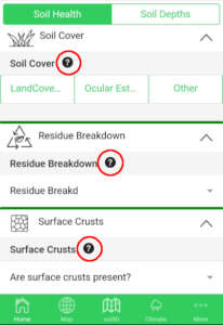
Soil Cover the percent of soil surface covered by live plants, dead plant material, or organic mulch. This indicator can be evaluated in 3 different ways:
– Landcover Transect – transfers the completed information the user has reported in the LandCover module to display Total Cover Percent
– Ocular Estimate – allows the user to record multiple ocular estimate observations
– Other – allows for other methods of estimating Cover Percent (in 40 characters or less)
Residue Breakdown is the rate of decomposition as indicated by many environmental and soil conditions. These include soil microbial community, chemical and physical characteristics of the residue, soil water content, soil temperature, and soil aeration. The indicator is evaluated by comparison of expectations for similar soil, topography, climate, and residue type, on a scale of “much greater than expected” to “none or very little.”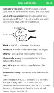
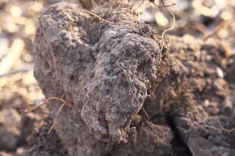
Surface Crusts are thin layers of soil at the soil surface that have different physical and/or chemical characteristics than the underlying soil. There are 3 types of crusts: Biological, Chemical, and Physical. Physical crusts can be either Structural (formed by water) or Depositional (caused by deposited soil particles). Surface crusting is evaluated by:
– Whether crusts are present
– Thickness of layer
– Level of development – determined by applying force to crust sample
– Extent percentage
Ponding is the soil characteristic that shows the extended periods that standing water stays on the soil surface. It can be an indicator of crusts, poor soil structure, poor aggregate stability, compaction or inherent soil properties, and/or landscape position. Ponding is measured by duration.
Root Restriction is a near-surface layer of dense soil that is hard for plant roots and water to penetrate. These can be naturally occurring or human-caused. Root restriction measurements can be recorded in 3 ways:
– Measure Penetrometer
– Measure Other – such as wire flag, sharp rod, or shovel
– Describe Layer – by entering depth to the top of compaction layer, thickness, level of development, and extent
Aggregate Stability is the ability of soil aggregates to resist collapsing into smaller pieces due to tillage, wind, or water erosion. This indicator is measured by using the Cylinder method, Strainer Method, and/or a Soil Stability Kit.
Soil Structure is the grouping of soil particles into aggregates. These can occur in different patterns, resulting in different soil structures. They influence the pore space in the soil and how easily air, water, and toots can move through the soil. This indicator is evaluated by identifying the soil structure type. Multiple observations can be made:
– Granular
– Subangular Blocky
– Angular Blocky
– Lenticular
– Platy
– Wedge Prismatic
– Columnar
– Single Grain
– Massive
Soil Color is a physical soil property that gives an indication of the various processes occurring in the soil as well as the type of minerals in the soil. The indicator records the Munsell color notation at each depth. This can be determined with a Munsell book, or the app using a camera and WhiBal card or yellow post-it note as a color reference. Multiple observations can be recorded for each method.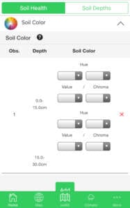
Plant Roots anchor the plant, absorb water and nutrients, store food and nutrients, and move water and nutrients to the stem. This indicator is evaluated by checking all the root characteristics that apply, such as:
– Whether roots are covered in rhizosheaths
– Are part of soil aggregates
– Are healthy, fully branched, etc.
Biological Diversity affects soil structure and therefore water availability by performing many vital functions such as converting dead and decaying organic matter and minerals to plant nutrients. This indicator is evaluated by identifying the amount of soil diversity present, from “numerous” to “none.”
Biopores are channels in the soil that are formed by the activity of plant and animal life. They allow air and water to move through the soil and are pathways for root growth. The indicator is evaluated by recording the number of biopores in a 10 x 10 cm area.
Runoff and Erosion reflect soil movement and loss from the site. It can be used to detect excessive runoff, which can reduce the water availability for plants. The indicator is evaluated by identifying the extents of three characteristics found at the site:
– Water Flow Pattern
– Rills
– Gullies
Soil Smell may indicate numerous inferred characteristics of the soil. This can mean the presence or lack of biological activity and/or poor soil structure. The indicator is determined by selecting one of three distinct scents:
– Fresh, Sweet earthy smell
– Little or no smell
– Swampy, stagnant, or mineral smell
Soil Tests
- Soil Organic Carbon (SOC) / Soil Organic Matter (SOM) SOC is a measurable component of SOM. Reductions to SOM levels lead to a deficiency of nutrients for crops, a decrease in soil aggregate stability and water holding capacity, and a decline in soil biological activity. This indicator evaluation is found by entering the SOC or SOM % values, and the method of data collection used.
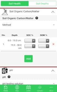
- pH is a measure of soil acidity or alkalinity. pH levels that are too high or too low can cause nutrient deficiencies, lower crop yield, and lower soil biological activity. The indicator’s evaluation entails measuring the soil pH value, noting the types of liquid added to the soil, and defining the method used to determine pH.
- Soil Electrical Conductivity (EC) is a measure of the amount of salt in the soil, i.e. Soil Salinity. It influences the water and nutrient availability for both plants and soil organisms. Very high levels of EC can reduce crop yields and prevent some crops from growing altogether. You can measure Soil Electrical Conductivity by using an EC pocket meter.
For more information about each indicator in the LandPKS app, tap the question-mark icons:
Further reading
Monitoring Manual for Grassland, Shrubland, and Savanna Ecosystems
Soil Health Assessment|NRCS Soils
Soil Quality Indicator Sheets|NRCS Soils
J.E. Herrick et al, “A strategy for defining the reference for land health and degradation assessments,” Ecological Indicators 97: 225-230.
Other LandPKS Trainings
Vegetation & LandCover training videos


Jornada Experimental Range
Range Management Research Unit
2995 Knox St.
Las Cruces, NM 88003-0003, USA
Mobile App | Data Portal | Knowledge Hub | Habitat Hub | Learning Collections | Blog | About | Contact | Support