Note: the Android version is currently out; the iOS version is coming soon.
“Understanding a soil’s properties and how it functions at a specific location is critical for informing sustainable land management practices. However, current sources of soil information are not accurate enough to meet that goal,” explains Jonathan Maynard, a soil scientist at the University of Colorado at Boulder who works on LandPKS and led the soilID redesign. Jonathan continues, “the value of soilID is that, through measuring a few key soil properties at a site and then linking that soil information to existing soil maps, we can minimize the uncertainty associated with those maps by identifying the most likely soil type at a location.” When users can identify their soil type, it is like handing them a key they can use to unlock a treasure trove of information about their soil and allows them to gain a better understanding of how their land will respond to different types of management.
We sought to accomplish two main things with the new version of SoilID. The first was to make soil information easier for the user to interpret, through a redesign of the visual interface. The second was to provide users with additional sources of soil information to help inform decision making, including improved links to ecological site information and additional soil interpretation from SoilWeb. Recognizing recent, continuing improvements in digital soil mapping and the potential utility of those products, we now also provide a link to SoilGrids v2.0 which provides soil property predictions at a 250-meter spatial resolution.
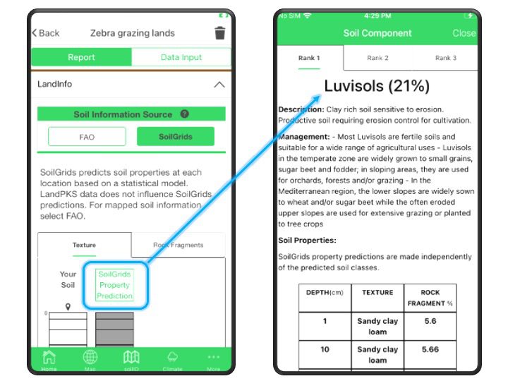
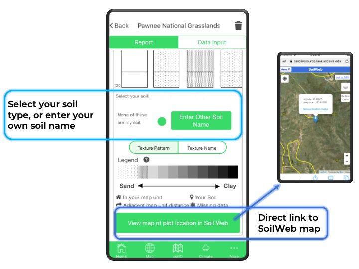
In addition, this new version of SoilID also allows users to select their soil from the list of mapped soil types, or to enter the name of a soil that is not mapped in that area. This new feature provides valuable feedback to soil mappers that can be used to help improve future updates to existing soil maps. Identifying the soil type also allows users to access more detailed soil information that is not always possible to measure in the field, including many physical and chemical properties or ecological site information.
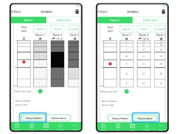
The visual redesign presented some challenges when it came to representing soil texture, one of the most important properties that influences how a soil functions. Soil texture is made up of 3 particle size classes (sand, silt, and clay), and the distribution of those 3 classes is typically represented in a pyramid, difficult to display in a linear way. Thus, when viewing soil texture profiles, it can be challenging to interpret the relative similarity of soil texture between the soil types mapped in an area.
We began the redesign process by surveying various soil scientists and other experts on different ways of displaying soil texture information. Through the survey, we were able to identify two types of users: those who wanted to see relative textures in a single legend, and those who wanted to know the individual texture classes.
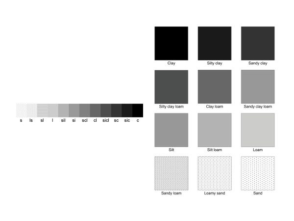
“In the new version of soilID, we display soil texture on a linear gradient based on mean particle size diameter, which allows us to visualize the soil based on the relative difference in the amount of sand versus clay,” Jonathan explains. This then relates to the general differences in soil function, such as water holding capacity or general nutrient availability. For those who want to see the individual texture classes, we provide another legend, using the texture class abbreviations.
Ultimately, Jonathan says, “the idea behind soilID is to provide the most accurate soil information at a site and to make that information interpretable to the end user.” Download the most recent version of LandPKS today and let us know what you think!
Further Reading
“Taking the Guesswork out of Soil Identification”
On April 15 -17th the Noble Research Institute in Ardmore, Oklahoma hosted a LandPKS feedback workshop. The main goal of the workshop was to solicit thoughts, ideas, and feedback on how to improve the LandPKS app, including the current modules and features, as well as our upcoming redesign of the LandPKS app. Attending the workshop were LandPKS staff, Noble Research Institute staff, pasture and range consultants, seed company and agricultural industry representatives, The Nature Conservancy staff, Natural Resources Conservation Service soil scientists, and ranchers.
The workshop began on the 15th with an introduction to the LandPKS app and future additions to it including a SoilID function, and LandManagment and SoilHealth modules. On the 16th the day was divided into four sessions where participants could provide feedback about different aspects of the LandPKS app including geospatial components, input modules, outputs and interpretations, privacy and data sharing, interface and navigation, and social networking. On the 17th, the workshop ended with a discussion on what should be prioritized for future LandPKS development.
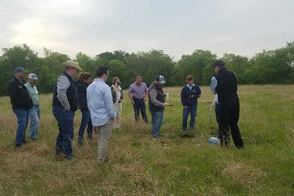
The feedback received over the three-day intensive workshop was invaluable in shaping the future of the LandPKS app; ensuring that it is both usable and useful in sustainable land management within the United States. The LandPKS team thanks everyone who gave their valuable time to join us. It is very much appreciated!
It is also important to thank the Noble Research Institute for opening their doors to us for this workshop. Lloyd Noble established the Noble Research Institute in 1945 to revitalize agriculture after the Dust Bowl and deliver solutions to great agricultural challenges. The Noble Research Institute focuses on basic, translational, and applied research that will help farmers and ranchers improve land stewardship and productivity. The institute has seven research and demonstration farms, covering 14,000 acres in southern Oklahoma.
The LandPKS app is free and available on the Google Play Store and iTunes Store. The LandPKS app was developed by the LandPKS Team for the Land-Potential Knowledge System (LandPKS) with support from USAID and USDA-ARS. Please contact us with any questions, comments, or feedback.
The LandPKS team is committed to user-centered app design, and a major part of this includes soliciting feedback from our users to help improve the LandPKS app to meet their needs. The LandPKS team conducts a bi-annual online user survey to gain feedback about various components of the app. We conducted our latest bi-annual survey last month and want to say thank you to all our users who contributed their thoughts and ideas!
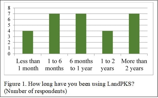
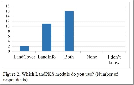
Results in Figure 1 show that many of our users are long time users of LandPKS and have been using the app for more than 2 years, while others are new to LandPKS. We also asked our users which LandPKS modules they use most in their work (Figure 2). Importantly, most of our users are utilizing both the LandCover and LandInfo modules to characterize the soil and monitor vegetation. Additionally, a handful of users indicated they had collected data on more than 300 sites using LandPKS!
We also asked users a variety of questions about the new LandPKS App Version 3.0 as well as their thoughts on modules we are currently designing and programming. Users reported that they are very likely to use the upcoming SoilColor and Land Capability Classification Modules which will be released in the next few months. Further, many users stated that they would like to be able to download PDF reports and reshape files of their data from the LandPKS Data Portal. As a result of this feedback, we plan to integrate these functions into the Data Portal soon. Our users have also found the newly available results in the LandPKS App Version 3.0 helpful to their work. Particularly, users find the bar chart data summaries in LandCover helpful as well as the visual summaries of soil texture and rock fragment volume by depth.
The LandPKS app helps users make more sustainable land management decisions by assisting users to collect geo-located data about their soils, vegetation, and site characteristics; and returning to users results and information about their site.
The LandPKS app helps users make more sustainable land management decisions by assisting users to collect geo-located data about their soils, vegetation, and site characteristics; and returning to users useful results and information about their site. The LandPKS app is a global app that can be used in any location around the world. As visible on the LandPKS Data Portal, there have been LandPKS sites completed on 6 continents!
While being a global app has major advantages, it also comes with design challenges to assist our global users. To address this, we have developed three major design guidelines:
- Simplicity
- Usability
- Usefulness
To maximize simplicity, the LandPKS team aims to minimize the number of components and screens. We aim to break tasks into manageable chunks so that users are not overwhelmed. Additionally, we strive to make the LandPKS app be as visual as possible by using simple graphics and charts. For example, in the vegetation monitoring module, LandCover, users select vegetation types based on simple images:
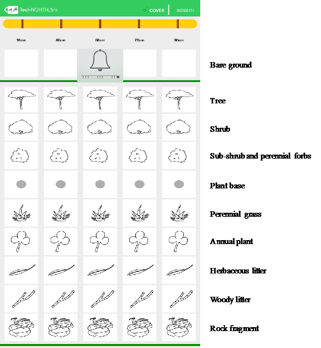
Selection of vegetation and cover types in the LandCover module of the LandPKS app. Users choose from these simple images to determine what types of vegetation are present at their site.To maximize the usability of the LandPKS app we aim to design the navigation of the app to be intuitive and seamless. Most importantly, the LandPKS app is designed and built to be usable by non-technical experts. Therefore, we aim to use minimal technical language, include question marks with brief text and/or graphical explanations, and include explanatory videos when needed. For example, in the LandInfo module, we include videos that help explain how to hand-texture the soil for a user who is not a soil scientist and may be unfamiliar with how to hand-texture the soil.
Lastly, we focus on the usefulness of the LandPKS app globally. This includes soliciting feedback from our users in order to help mold the LandPKS app to meet their needs. The LandPKS team conducts a bi-annual online user survey to gain feedback about various components of the app. We also spent a month in Tanzania last year testing the app with smallholder farmers and agricultural extension agents, making sure they found the app useful and were able to understand the outputs.