Note: the Android version is currently out; the iOS version is coming soon.
“Understanding a soil’s properties and how it functions at a specific location is critical for informing sustainable land management practices. However, current sources of soil information are not accurate enough to meet that goal,” explains Jonathan Maynard, a soil scientist at the University of Colorado at Boulder who works on LandPKS and led the soilID redesign. Jonathan continues, “the value of soilID is that, through measuring a few key soil properties at a site and then linking that soil information to existing soil maps, we can minimize the uncertainty associated with those maps by identifying the most likely soil type at a location.” When users can identify their soil type, it is like handing them a key they can use to unlock a treasure trove of information about their soil and allows them to gain a better understanding of how their land will respond to different types of management.
We sought to accomplish two main things with the new version of SoilID. The first was to make soil information easier for the user to interpret, through a redesign of the visual interface. The second was to provide users with additional sources of soil information to help inform decision making, including improved links to ecological site information and additional soil interpretation from SoilWeb. Recognizing recent, continuing improvements in digital soil mapping and the potential utility of those products, we now also provide a link to SoilGrids v2.0 which provides soil property predictions at a 250-meter spatial resolution.
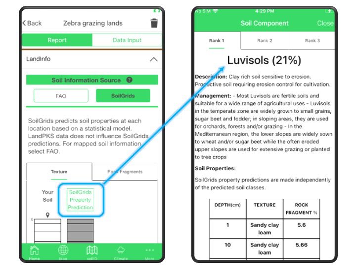
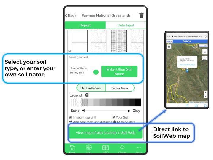
In addition, this new version of SoilID also allows users to select their soil from the list of mapped soil types, or to enter the name of a soil that is not mapped in that area. This new feature provides valuable feedback to soil mappers that can be used to help improve future updates to existing soil maps. Identifying the soil type also allows users to access more detailed soil information that is not always possible to measure in the field, including many physical and chemical properties or ecological site information.
The visual redesign presented some challenges when it came to representing soil texture, one of the most important properties that influences how a soil functions. Soil texture is made up of 3 particle size classes (sand, silt, and clay), and the distribution of those 3 classes is typically represented in a pyramid, difficult to display in a linear way. Thus, when viewing soil texture profiles, it can be challenging to interpret the relative similarity of soil texture between the soil types mapped in an area.
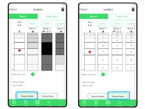
We began the redesign process by surveying various soil scientists and other experts on different ways of displaying soil texture information. Through the survey, we were able to identify two types of users: those who wanted to see relative textures in a single legend, and those who wanted to know the individual texture classes.
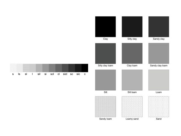
“In the new version of soilID, we display soil texture on a linear gradient based on mean particle size diameter, which allows us to visualize the soil based on the relative difference in the amount of sand versus clay,” Jonathan explains. This then relates to the general differences in soil function, such as water holding capacity or general nutrient availability. For those who want to see the individual texture classes, we provide another legend, using the texture class abbreviations.
Ultimately, Jonathan says, “the idea behind soilID is to provide the most accurate soil information at a site and to make that information interpretable to the end user.” Download the most recent version of LandPKS today and let us know what you think!
Further Reading
“Taking the Guesswork out of Soil Identification”
Like many of us around the world impacted by COVID-19, the LandPKS team is adapting to our new circumstances of working and learning from home. In an effort to make a small contribution to assist those looking for at-home resources for the whole family, LandPKS is starting a video series for learners of all ages. In the video series, you can discover how to use LandPKS to better understand the land around where you live, keep records, and monitor changes in soil health and vegetation.
We hope these videos can help support distance learning for students of all ages, families, and teachers during this time. The video series will encourage exploration and hands-on learning with the LandPKS mobile app. Just like the LandPKS app, the videos are designed to be used anywhere in the world.
The first video in the series explains why soils are important and how to use LandPKS to identify your soil texture. The video also demonstrates how to find out what types of soil are near your location or a location anywhere in the world. You can watch the video on the LandPKS YouTube Channel.
Stay tuned for more videos!
The knowledge engine of LandPKS supports land use planning, land restoration, future agricultural scenarios, climate change adaption, and conservation programs. However, a critical first step in using our integrated suite of smartphone applications includes the evaluation of soil and vegetation properties. As soil serves as the media for growth for all kinds of plants, identification of soil properties is vital for land managers, policy makers, and researchers in order for them to assess land potential.

Soil texture is considered one of the soil’s most important properties, influencing nearly all soil processes and functions. Soil texture is defined by the relative fractions of sand, silt, and clay-sized particles in a soil sample. Soil is often divided into 12 soil texture classes, allowing for communication of soil type amongst land resource specialists. Each particle type has benefits to plant growth, yet sometimes can be unfavorable when only one soil class (all sand, for example) makes up the majority of the soil sample. For example, clay holds water well and is usually fertile. However, clays swell when they get wet (limiting the water available to plant roots), and harden when dry (becoming difficult to manage). Deep sands drain easily and do not hold water effectively. Silt-sized grains retain water and nutrients, but can easily become water-logged and prevent movement of water, air, and roots throughout the soil profile. While most soil types can be managed, often Loam is considered the most desirable for plant growth because Loam contains equal parts of sand, silt, and clay. Different particle sizes allow for air, water, and roots to easily move through the soil, with Loam having enough sand to drain well, yet also enough clay and silt to hold onto water and nutrients.
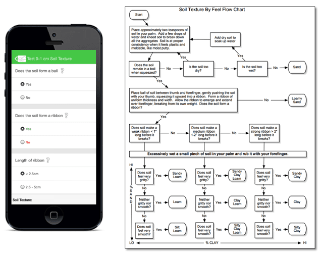
Soil texture flow chart
The LandInfo module of LandPKS walks users through estimation of texture by probing and working the soil. Users are asked to take a sample and test it for grittiness (sand), smoothness (silt), and stickiness (clay). Currently, the LandInfo module streamlines steps from a soil texture-by-feel flow chart which tests the relative fraction of sand, silt, and clay. However, through feedback from our trainings we have learned that often the user questions accuracy of their own texture-by-feel estimates. Our next steps to help address this issue include: (1) evaluating the accuracy of these texture-by-feel estimates, and (2) improving our decision support tools to allow users additional manipulative tests shown to differentiate between texture classes. Look for the results of these steps in the near future!

Shawn Salley