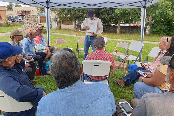
The two-part workshop “LandPKS: A Tool for Producers” took place on July 23rd, 2021 in San Luis, Colorado, and on the surrounding lands. Organized by collaborating partners from Colorado Open Lands, USDA-ARS, NRCS, and Colorado State University, the purpose of the workshop was to introduce land managers in the San Luis valley to using LandPKS to access data and information to help support management decisions.
The first part took place under a tent in the courtyard of a community center in San Luis, and consisted of a conversation about land management challenges in the San Luis valley and an introduction to using LandPKS. Settled under the tent holding cups of coffee, we began with introductions and a casual conversation about priorities and challenges in the valley. When it came to land management challenges in the area, the answer was nearly unanimous: water. Many of the workshop participants had been struggling with drought since 2002. “Runoff is happening earlier and earlier each year. There’s too much water too early and not enough when we need it,” one participant, a rancher, said.
The local wildlife has changed its patterns due to lack of water, another participant added. He had observed a reduction of wildlife and beneficial insects. “Creeks are drying out and riparian areas are suffering,” he said. “There is also very little topsoil and soil organic matter here,” another participant chimed in. Lack of topsoil and soil organic matter can slow down the time it takes for water to infiltrate the soil, and the conversation shifted to manure and ways to make the most of the available water. We concluded the discussion in agreement about the importance of ditch maintenance.
© LandPKS
“You don’t have to send your soil to a lab to learn what it is and observe if it’s getting better,” said Jeff Herrick, LandPKS Global Lead. He provided an overview of the varied possible uses of LandPKS: “It’s important to know about your soil for everything from septic design, to rangeland management, to finding good soils for adobe brick fabrication.” The San Luis valley has very diverse soils, which makes it all the more important for land managers there to know what soils they have on their land. This knowledge enables them to identify the most productive soils on their land so that, for example, increasingly limited irrigation resources can be allocated.
We walked through how to get set up on LandPKS and create a site. After a brief introduction to the LandPKS modules and functions, including the LandInfo, Vegetation, and Habitat modules, one participant, who was learning on another person’s device, said, “maybe I’ll finally get a smartphone now!”
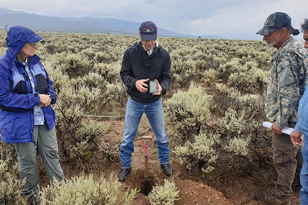
Part two of the workshop was a field demonstration of how to use LandPKS to learn about the soil at a specific site, which took place on a local rancher’s land. Undeterred by the rain, we sampled soil from a two-foot hole which we had pre-dug with the landowner. Rolling the soil into balls and pressing it into ribbons, we observed the high clay content of the soil. In addition, we used LandPKS to access local ecological site information at that specific spot.
© LandPKS
During the closing reflections in the field, several participants said that what they had learned at the workshop was useful and expressed interest in a follow-up workshop later this year. Particular interest in the Vegetation and Habitat modules was expressed. When asked what the most important thing they had learned at the training was, one participant said that he learned how to use LandPKS to determine how to best use his land while also enhancing its ecology. Another participant said, simply, “That this tool exists!”
See details about upcoming in-person training events and webinars here.
LandPKS supports ranchers, rangeland managers, and other land managers with open-source tools that allow them to easily access knowledge and information and to collect, share, and interpret their own soil, vegetation cover, and management data. This webinar series targets rangeland managers and others who are interested in learning how to use LandPKS and in exploring the app’s new Habitat and Soil Health modules in a rangeland management context. Each of these three, 45-minute webinars will focus on a different aspect of using LandPKS on rangelands: identifying land potential, monitoring vegetation, understanding habitat, and monitoring soil health.
This series was produced in collaboration with our partners at The Nature Conservancy in Colorado. An NRCS Conservation Innovation Grant supported this work.
Part 1: Learning about your Land and its Potential with LandPKS
Time stamps: Live demo at 15:31, Q&A at 28:52
Part 2: Monitoring Vegetation and Understanding Habitat with LandPKS
Time stamps: Adaptive rangeland management intro at 5:46, live demo at 18:30, Q&A at 38:50
Part 3: Monitoring Soil Health with LandPKS
Time stamps: Soil health intro at 4:30, live demo at 10:50, Q&A at 28:56
Further Resources
Intro to the LandPKS Habitat Module & Habitat Factsheets
Intro to the LandPKS SoilHealth module (new videos coming soon)
The greater prairie chicken, a species found in the Great Plains of North America, has an elaborate mating ritual. In the spring, males gather on breeding sites, known as leks. Each male defends a small territory on the lek. To attract females, the males stamp their feet rapidly, make booming sounds with their air sacs, and leap into the air with loud cackles. After having mated, the females retreat to their nearby nests, where they lay an egg. The next morning, they return to the lek and mate again, usually with a different male. Lekking mostly occurs just before and after sunrise in March and April, making early spring mornings the best time to observe greater prairie chickens.
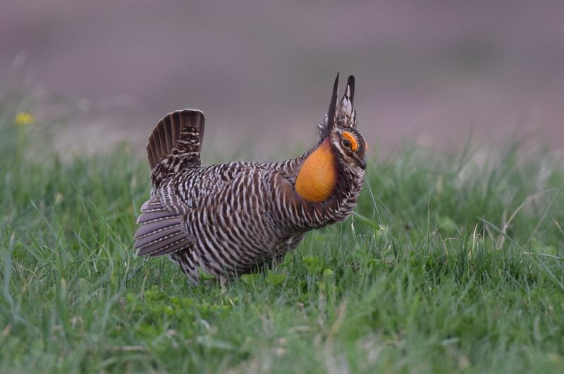
Photo credit: © Andy Reago & Chrissy McClarren
Terri Schulz of The Nature Conservancy in Colorado has talked with ranchers about the chickens, their sensational courtship display, and their habitat requirements. Once a land manager knows the needs of the prairie chicken, they can begin to adjust management to improve the habitat. Prairie chickens usually nest within a mile of the lek, and because they build their nests hidden in tall grass, it is beneficial when some areas near the leks are left ungrazed during the nesting season (e.g., before July in Colorado). This hiding cover is especially critical during the nesting period when nests and chicks are most vulnerable to predation.
“Ranchers love their land, and they know a lot about how to improve prairie conditions and what their livestock need. But they don’t necessarily know what their wildlife needs,” Terri says. Over the years, Terri found herself communicating a lot of habitat information one-on-one to land managers. She began to think about ways that information could be made more easily and systematically available. As a LandPKS user, she had the idea to provide habitat information through a tool which many land managers already found valuable.
The beta version of the Habitat Module was released in October 2020, and LandPKS users are invited to test it and provide feedback (including recommendations for additional species). The module conveys what types of management actions work best for species and flags activities that could be detrimental to them. “No big changes in management are required,” Terri explains. “It’s not just about having tall grass, or about not grazing. There are some species that like having the grass grazed hard during the year. Some species have evolved to nest on bare ground. If we want to have the full diversity of species, we need to have a diversity of habitat types.”
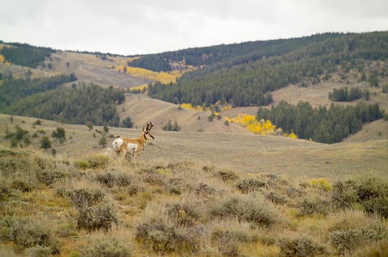
Another example of how easy adjustments can benefit species is making fences less impactful for pronghorn antelope. Just the simple act of leaving gates open or, when building new fencing, ensuring fencing design is “wildlife-friendly,” can allow them to more easily move through the landscape. “Ranchers can use temporary fencing and other ways to move livestock which will also leave the landscape more permeable to wildlife movement,” Terri explains.
© Mark Godfrey, courtesy of The Nature Conservancy
The Habitat Module also contains information about species that any landowner can manage for, including anyone with a garden. By building Habitat within the LandPKS app, the utility of LandPKS is opened to a broader audience, people that are motivated by wildlife goals. Terri elaborates: “The monarch butterfly, for example, is dependent on milkweed, and the species benefits just by this one type of plant being available. So make sure you plant native milkweeds in your yard!”
The LandPKS-Nature Conservancy collaboration continues in full swing, with a series of webinars and additional species to be added in the new year. “This has been my favorite project of my entire career. The passion and desire to work on this project among the team members has been incredibly rewarding,” Terri reflects. She elaborates further, “A lot of land managers feel pride when they learn that they have been providing habitat to a species all along. The Habitat Module allows them to understand exactly what they’re providing, and how important that habitat is to certain plants or animals while meeting their livestock and vegetation goals.”
Terri Schulz is a Senior Conservation Ecologist at The Nature Conservancy of Colorado and an advisor to LandPKS.
Further reading:
About the LandPKS Habitat Module
About getting started using the LandPKS Mobile App
The Habitat Module’s Features and Functions
The Habitat module can help determine if you are fostering the conditions required for key species on your land. Habitat information and data collected in the app can be used to develop goals, guide management actions, and develop monitoring plans.
This teaser video briefly introduces the Habitat Module and its main features and functions:
Learn about Wildlife Species and their Habitat Requirements
Habitat currently includes a selection of 22 plants, mammals, birds, reptiles, and insects that occur in North America, including monarch butterflies, pronghorn antelope, and ornate box turtles. As soon as a plot is created, the app will display a list of species that may occur at the location based on the known range of each species. Selecting a species displays the habitat requirements. After you have collected vegetation or soil data, the app will display your data in the same table, side-by-side with the species’ habitat requirements.
See the species factsheets for in-depth information about habitat characteristics. The factsheets are available in two places: in the app (including offline) and in the Knowledge Hub on LandPotential.org.
In this video, meet the two main instigators of the LandPKS Habitat Module, Terri Schulz and Tegan May, and learn about why they thought it was important that data about soil and land be tied to information about wildlife species:
Designed for a Wide Range of Users
The LandPKS Habitat Module is designed for a wide range of users, including:
- Ranchers
- Farmers
- Wildlife enthusiasts
- Homeowners
- Educators
- Open space and other land managers
And anyone else who is interested in conserving and managing for wildlife habitats on their land. Habitat can be used for both planning and educational purposes, on ranches and in schools, in suburban neighborhoods and on wildlife preserves.
Get Started Using Habitat!
This video quickly demonstrates how to use the LandPKS Habitat Module:
Learn more about the Habitat Module, and access species factsheets, in the Knowledge Hub. Download the LandPKS mobile app in the Apple App Store or the Google Play Store.
Many thanks to our partners in developing the Habitat Module:
This work was funded by an NRCS Conservation Innovation Grant and matching private donations.
Protected areas cover nearly 13% of the earth’s surface, illustrating the critical importance of conserving biodiversity globally (Barua et al. 2013). However, wildlife habitat is not confined to protected areas and many wildlife species live and migrate in landscapes dominated by humans (Nyamwamu et al. 2015). Thus, not only is effective protected area management important for conservation but also maintaining human-dominated landscapes that can still function as wildlife habitat. The East African country of Kenya is world-renowned for its wildlife, with over 10% of the land in national parks and much more in community-managed wildlife conservancies (Western et al. 2015).
In Kenya, the Land Potential Knowledge System has been providing a valuable tool to help land managers, researchers, and rangeland managers effectively conserve and restore biodiversity. LandPKS is a free, open-source, mobile app that provides users with information about the potential of their land, including identifying the soil type and monitoring vegetation growth or degradation. Using the Land Cover module, a user can track changes in vegetation cover, including the restoration of important fodder species for both livestock and wildlife, as well as monitor the abundance of invasive, destructive plant species. The LandPKS app makes monitoring important areas for both wildlife and livestock easy and convenient, with instant results delivered directly to the user’s phone.
Managing land more effectively for wildlife also means managing land more effectively for communities that also rely on the same land for their livelihoods. LandPKS can help identify areas that are more suitable for rangeland, agriculture, wildlife conservation, and other uses. Matching land with suitable land-uses is critical for natural resource governance because it helps promote sustainable conservation and livelihoods simultaneously. Further, matching a land-use to a suitable area will increase the ability of communities, and wildlife, to adapt to changing environmental conditions, such as increased drought frequency and severity. Further, in mixed-use areas of Kenya, such as the case study below, maximizing fodder species, and reducing undesirable species has benefits for both wildlife and livestock.

In the Laikipia and Samburu Counties in Kenya, complex historical land tenure systems have resulted in a patchwork of private ranches, community-owned conservancies, and open rangeland. Here, rangeland degradation manifests itself through increased bare ground and replacement of perennial grasses by undesirable species, such as Acacia reficiens. LandPKS is being used here to help assess the success of invasive species control methods. LandInfo was used to describe selected treatment sites and provided data for biophysical matching with control sites. LandCover was then used to collect data on various vegetation metrics. Using LandPKS in Westgate and Kalama Conservancies helped to identify, match, and assess treatment and control plots for large-scale mechanical clearing of unwanted species and reseeding projects. This type of vegetation restoration benefits livestock and wildlife and can help conserve critical biodiversity. LandPKS is one potential tool that can contribute to wildlife conservation, as well as effective natural resource governance and land use planning.

Barua, M., Bhagwat, S. A., & Jadhav, S. (2013). The hidden dimensions of human-wildlife conflict: health impacts, opportunity and transaction costs. Biological Conservation, 157, 309-316.
Nyamwamu, R.O., Mwangi, J. G., & Ombati, J. M. (2015). Untapped potential of wildlife agricultural extension mitigation strategies in influencing the extent of human-wildlife conflict: a case of smallholder agro-pastoralist in Laikipia County, Kenya. International Journal of Agricultural Extension, 3(1), 73-81.
Western, D., Waithaka, J., & Kamanga, J. (2015). Finding space for wildlife beyond national parks and reducing conflict through community-based conservation: the Kenya experiences. Parks, 21(1).