LandPKS Learning
Knowledge Hub
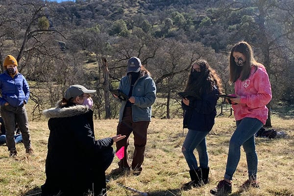
Using LandPKS for Rangeland Monitoring: Soil, Grazing, and Rangeland Management
A high school-level lesson plan that explores the following questions: What is rangeland? Why should we monitor rangeland? What is the difference between quantitative and qualitative data? What does ground cover tell us about our soil health? How does grazing affect ground cover? What is erosion and how does it happen? How does our soil connect to climate?
This lesson plan is designed to introduce high school students to rangeland management through grazing, and teach them how to monitor rangeland health. Students use LandPKS to explore land cover as an indicator of soil health and overall ecosystem health.
Essential questions this lesson plan explores:
- What is rangeland?
- Why should we monitor rangeland?
- What is the difference between quantitative and qualitative data?
- What does ground cover tell us about our soil health?
- How does grazing affect ground cover?
- What is erosion and how does it happen?
- How does our soil connect to climate?
Access the “Using LandPKS for Rangeland and Species Monitoring: Changing Ecosystems” lesson plan.
The Sequoia Riverlands Trust (SRT) developed this lesson plan as part of their EARTH Academy program for high school students in the San Joaquin Valley in California. Though it was originally designed to be conducted on SRT-owned preserves, EARTH Academy lesson plans are adaptable, to be used across different schools and geographical locations.
EARTH Academy aims to bring more outdoor education to area schools. Using science education with an emphasis on the environment and the outdoor world, EARTH Academy prepares students for real careers. Learn more about EARTH Academy and the LandPKS collaboration with EARTH Academy.


Jornada Experimental Range
Range Management Research Unit
2995 Knox St.
Las Cruces, NM 88003-0003, USA
Mobile App | Data Portal | Knowledge Hub | Habitat Hub | Learning Collections | Blog | About | Contact | Support