Over the past several months, our LandPKS Tanzania Country Coordinator Elifadhili Daniel has been working hard in partnership with the World Agroforestry Center (ICRAF) to get the word out about LandPKS as a tool for land-use planning and agricultural extension.
For Tanzanian land-use planners, LandPKS has become a valuable decision-making tool. LandPKS is being used by the National Land Use Planning Commission (NLUPC) and the USAID Land Tenure Assistance Project to carry out soil assessments. Since its introduction, the NLUPC has been using the LandPKS Land Capability Classification (LCC) tool to collect soil characteristics data. These data are used to assist in decision making on sustainable land use planning and management in NLUPC project areas. LandPKS has also informed village level land use plans and helped villages formalize land tenure through the Certificate of Customary Right of Occupancy.
Professionals in the agriculture sector in Tanzania have also found how LandPKS can be used as an information resource for agricultural extension. Since October 2018, Daniel has trained over 1,800 individuals including students at agricultural colleges, researchers at the Tanzania Agricultural Research Institute (TARI) and the Agricultural Seed Agency (ASA), nonprofit organizations, and agricultural extension officers in 22 regions across Tanzania. After trainings, agriculture professionals expressed how LandPKS can improve their ability to provide farmers with more accurate recommendations.
Government extension agents from the Manyara region of the Hanang District entering soil texture information in the LandPKS app.
Christian Msipolosi-Songea, a District Agricultural and Irrigation Cooperative Officer in the Ruvuma region noted that “the most intriguing feature about this technology is its ability to provide site-specific information on climate and soil characteristics which will enable us to provide accurate advice to our farmers for decision making on choice of crop varieties, use of inputs like agrochemicals and seed types, and how to [help] cope with challenges of our changing environment’’.
Agriculture professionals also pointed out that an increasing number of families have access to smartphones which opens the possibility for extension agents to teach farmers to use LandPKS. LandPKS is available in Swahili, making it possible for farmers to use the app in their own language. Daniel’s trainings have also prepared extension agents to train other agriculture professionals and farmers to use LandPKS. Thanks to ICRAF and Daniel’s efforts for helping us realize our vision of global access to sustainable land management knowledge.
Elifadhili Daniel is our LandPKS Country Coordination Officer for Tanzania. He is a crop scientist, with a Master of Science Degree in Crop Science from Wageningen University and Bachelor of Science in Agriculture from Sokoine University of Agriculture. Daniel has more than 10 years’ experience working with farmers as an agricultural extensionist, three of which he worked as a researcher for AfricaRice where he was involved in developing cost effective, culturally and socially acceptable parasitic weed control strategies for resource-poor rice farmers in Tanzania. He has interacted and established a network with various agricultural stakeholders including input suppliers, researchers, Agricultural training institutes, local NGOs and District Agricultural Offices in Tanzania. His LandPKS work in Tanzania involves, among many things, training farmers, extension, development and researchers on the use of the LandPKS mobile app, identifying and communicating improvements to the LandPKS development team and developing additional training and outreach materials in Swahili.

Due to shortage of extension officers in many villages of Tanzania and high costs for conducting laboratory soil testing, Daniel is motivated ensure LandPKS is rolled out and used as a decision tool for soil management by multiple stakeholders and users.

Photo 1: Soil samples collected and ready for hand texturing guided by the LandPKS app.
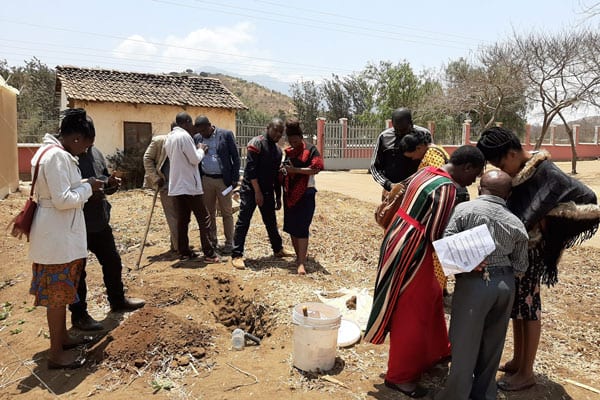
The LandPKS team spent three days last week in Kisarawe District, Tanzania training and testing the new Land Capability Classification (LCC) function of the LandPKS app. The LCC classifies the land into eight classes (from prime agricultural land to land that would be better used for livestock, wildlife conservation, or forestry) based on the potential productivity of the land. The class is determined by slope, soil texture, and seven different soil limitations such as soil depth, permeability, flooding, etc. We were joined in Kisarawe District by staff from Tanzania’s National Land Use Planning Commission (NLUPC) as well as Kisarawe District staff including land use planners, agricultural officers, and livestock specialists.
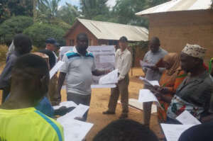
Photo 2: Dr. Charles Mkalawa with the NLUPC leading the LandPKS training with the village government and local farmers.
We spent three days in the Kisarawe District, which is a rural area just outside of Dar es Salaam, the largest city in Tanzania. On the first day, everyone visited the nearby village of Mtamba and the LandPKS team trained the national and district level staff, alongside local village government officials and farmers, on how to use the LCC function within the LandPKS app. We also discussed how the LCC can be integrated into land use planning to better match the land use with the land capability. On the second day, we visited the villages of Masanganya and Marumbo in the Kisarawe District. Dr. Charles Mkalawa from the NLUPC conducted the training with the village governments and farmers on the second day. On the third and last day, we visited Mhaga, and the staff from the NLUPC and Kisarawe District conducted the entire training! It was excellent to see how quickly the staff understood the LCC function and the LandPKS app and were able to train others within three short days. The staff is now well trained to help others learn how to use the LandPKS app for biophysical characterization of the land for land use planning. All of us at the LandPKS team were very impressed and the NLUPC and Kisarawe District staff are looking forward to future collaborations and implementation of the LandPKS app for land use planning efforts in Tanzania and beyond.
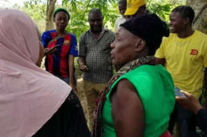
Photo 3: Staff from the Kisarawe District leading the LandPKS training.
The LandPKS app is free to download for both Android and iOS. Learn more about the LandPKS app on the landpotential.org website. Training resources, including guides and online training, are also available on the website. The LandPKS app was developed by the LandPKS Team for the Land-Potential Knowledge System (LandPKs) with support from USAID and USDA-ARS.
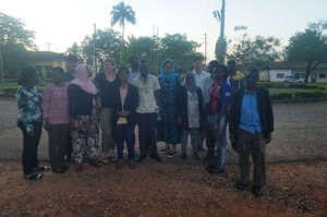
Photo 4: The LandPKS Team, NLUPC Staff, and Kisarawe District Staff as the sun was setting on our third day in Kisarawe.
In Tanzania, the Land Potential Knowledge System has been working with the National Land Use Planning Commission as well as USAID’s Land Tenure Assistance (LTA) Project to assist in effective land use planning and land tenure efforts. LandPKS is a mobile app that helps users identify their soil, and the potential productivity and long term agricultural sustainability of that soil. By identifying areas with sustainable agricultural potential, land-use planners can integrate biophysical assessments into their participatory land-use planning process. The LTA project is helping to revise village-level land-use plans. Once land use planning is complete, LTA is using a mobile technology called MAST (Mobile Application to Secure Tenure) to assist village members to attain a CCRO (Certificate of Customary Right of Occupancy) for their farms and properties. By integrating LandPKS soil information into their land-use plans, LTA and other land-use planners can make better decisions about which areas within a village are suitable for agriculture, and which are not. Focusing agricultural growth on soils suitable for sustainable agriculture not only increases farmer revenues and productivity but saves other village lands for other, less intensive uses such as grazing areas or forest reserves.
At the national level, Dr. Stephen Nindi, Director General of the National Land Use Planning Commission, is working with the LandPKS team to implement LandPKS tools in the future for the national land-use planning process. Tanzania currently uses a 6-step process for participatory land use management, involving community members and stakeholders at every step. On the biophysical side of the land-use planning process, Tanzania draws from the seven land capabilities classes. Categorizing the land into these seven classes helps planners to determine which livelihood activities are sustainable in which areas. For example, land capability class one refers to land that is suitable for all land uses with normal land management practices, such as flat, well-drained, and fertile land. LandPKS could play a key role in helping land-use planners classify land into these seven classes based on soil texture, soil water holding capacity, potential erosion risk, and potential productivity. While soil texture is not the only important soil characteristic, it can be a critical predictor of a land’s potential and its degradation risk. Implementing LandPKS in the land use planning process will simply, and cheaply, help the National Land Use Planning Commission include more biophysical data into their land-use planning process.
Therefore, LandPKS has a role not only in improving sustainable land management for farmers and pastoralists but also on a larger scale through the land use planning process. Matching appropriate land uses to their proper soil types can increase productivity and decrease land degradation, essential goals for long-term environmental sustainability.
How do local perceptions of land potential compare with soil types and textures measured with LandPKS?
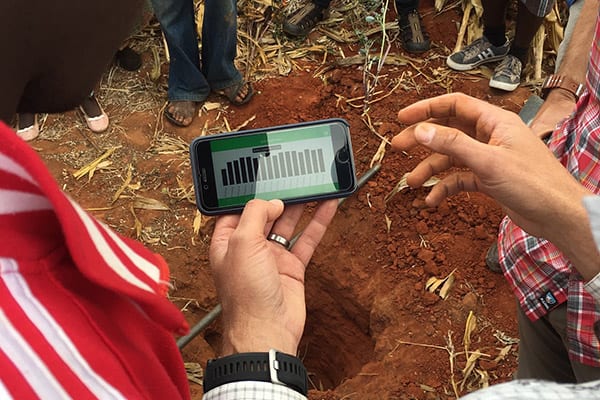 That is what we set out to figure out in the rural village of Lyamgungwe, Tanzania. We asked the village government officials and elders to identify two locations within their village: one with a soil that is highly productive and does well-growing maize, and one with a soil that is not very productive and where farmers have a hard time growing maize. The results were quite dramatic and the local perceptions were supported by LandPKS. The locally perceived productive soil was a Sandy Clay Loam until about 20cm depth where it turns into a Sandy Clay, and then a Silty Clay after 50cm. The locally perceived unproductive soil was a Clay for the first 20cm, then a Sandy Clay Loam, and a Loamy Sand after 50cm.

LandPKS results showed that the first soil can hold a lot more water (X vs Y cm in the top 70cm). Future LandPKS interpretations would also indicate that the first soil also has a higher potential infiltration, so it should be able to capture more water before it runs off. This type of information can be used to decide which land to – and not to – cultivate, which can help with land use planning for both agriculture and conservation.