At the beginning of the Covid-19 pandemic, Ben Munger, Director of Mitigation and Land Management at Sequoia Riverlands Trust (SRT), was listening to a podcast at home when something caught his ear. On an episode of the Art of Range podcast, LandPKS Global Lead Jeff Herrick was talking about the LandPKS app. “I immediately thought, wow, we can use this with our students!” Ben recalls. “It’s hands-on, quantitative data that they’ll be able to grasp right away.”
That spring, SRT began using LandPKS for vegetation monitoring on their preserves. “As a land manager myself, I find it really interesting, because we’re actually able to do comparisons between our preserves. On one of our preserves in particular, we’re able to show really clearly that LandPKS picks up grazing differences in terms of intensity. To actually show that quantifiably is really exciting,” Munger explains. They also began planning how to integrate LandPKS into their Earth Academy curriculum for local high school students.
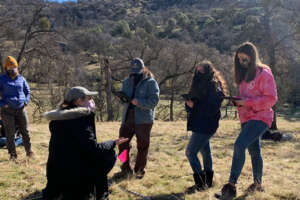
“The students could see the applicability of what we were doing”
© Sam Weiser, courtesy of Sequoia Riverlands Trust
Earth Academy introduces selected Tulare County high school students to rangeland ecology and aims to get them interested in careers in the environmental field. In 2020-2021, Earth Academy instructors took the high schoolers on field trips to five different SRT-owned preserves to collect rangeland monitoring data. Using LandPKS at Earth Academy worked well, explained SRT GrizzlyCorps fellow Alexis Wilkman, who was responsible for training the 9th-grade cohort how to use the LandPKS LandCover module. The picture-based design of the LandCover app made it especially intuitive to learn, Wilkman said, and the fact that LandPKS is a mobile app actually made it easier for students in that age group to learn how to use. The ability to immediately create a report following data collection was another appealing feature. Most of all, “the students could see the applicability of what we were doing down the line, and they said they had fun!”
© Sam Weiser, courtesy of Sequoia Riverlands Trust
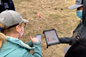
“After only a short demonstration, [the students] were able to collect data on iPads on their own,” said Wilkman. With funding from the EPA, Earth Academy was able to purchase an iPad for each student group. “Having the larger iPad screen is useful when working in a group, especially when you want to look at the report together,” Wilkman explained.
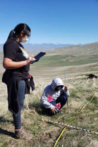
Using student-collected data
Reflecting on a highlight of the past year, Wilkman says, “we also had the opportunity to use the LandCover module to monitor the presence of the Striped Adobe Lily (Fritillaria striata) at our Lewis Hill Preserve.” At that particular preserve, there are two different populations of threatened lilies, and SRT established two different monitoring points. All of the student groups used a slightly modified LandPKS vegetation protocol (allowing an individual species to be identified) to assess both monitoring points. When the SRT staff corroborated the data afterwards, they found that the students’ evaluation was likely very accurate, and they used it to estimate the number of lilies in that area.
© Alexis Wilkman, courtesy of Sequoia Riverlands Trust
Earth Academy’s series of classes and field trips runs from October to May every year, and the curriculum was for the most part created by SRT Education Coordinator Sam Weiser. The curriculum, which consists of 8 modules, is designed to introduce students to soil health, carbon sequestration, climate change, and changing landscapes. The program usually has around 30 student participants (this year had slightly lower turn-out due to the Covid-19 pandemic).
Some challenges the SRT team has encountered while using LandPKS include the question of how to categorize different types of litter and cover, such as bone fragments, manure, lichen, and moss. While students enjoyed learning about soil texturing using the LandInfo module, they struggled to get accurate results using the soil color tool. All in all, LandPKS has proven to be a simple and effective tool for SRT. They will definitely continue to use LandPKS both on the land management team as well as with Earth Academy Students, Munger says.
LandPKS has created a mobile application that helps land managers collect, store, and analyze data in order to inform decision making, agricultural production, and vegetation monitoring and restoration. It does this through the use of the LandPKS Mobile app, which is free to download and use for both Android and iPhone. The LandPKS app currently has two modules: LandInfo and LandCover.
The major goal of the LandCover module is to assist users with collecting vegetation cover data using a point-intercept method. LandCover is designed to be a simple, user-friendly substitute for traditional paper monitoring sheets for vegetation cover. The only equipment needed is a meter\yard stick and the LandPKS app installed on a smartphone. First, the user designates a center point of the plot. Next, the user walks 5 meter\yards in one direction from the center, drops the stick, measures plant height, and establishes if there are canopy or basal gaps. This is then repeated at 10, 15, 20, and 25 meter\yards along that given transect. Lastly, this process is repeated in the 3 remaining transects. Overall, this method yields 100 points of vegetation cover data per plot in about 20 minutes.


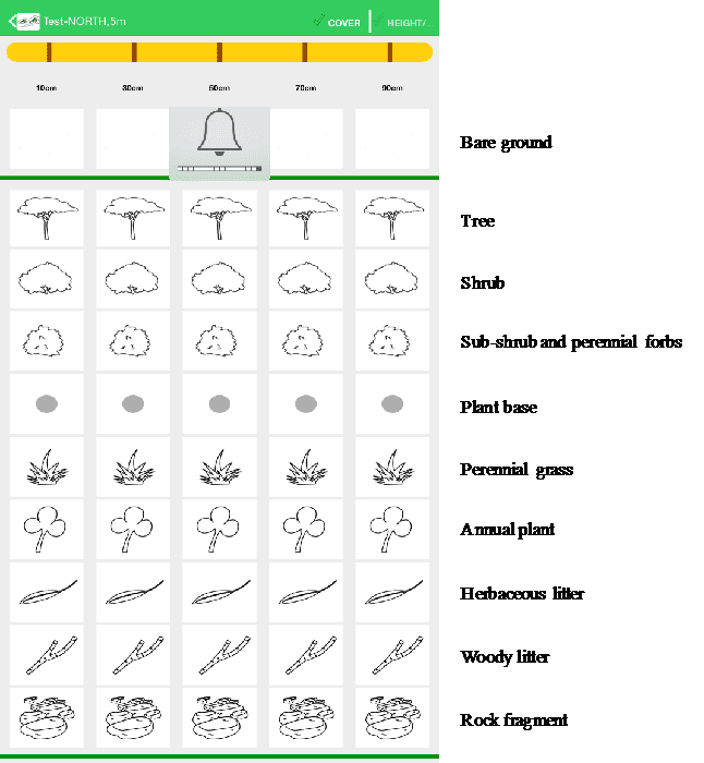
Selection of vegetation and cover types in the LandCover module of the LandPKS app. Users choose from these simple images to determine what types of vegetation are present at their site
Results are calculated immediately on the phone about the cover type, plant cover, canopy height, and gaps. In addition to receiving results on the phone. Users can also access their data on our open-source data portal. Further, a user can enter vegetation cover data for the same plot at various intervals and immediately get results about trends in vegetation cover. LandCover can be used globally, and the module is currently being used extensively in the rangelands Namibia and Kenya.
There are several important advantages of using the LandCover module for measuring vegetation cover. First, it gets rid of paper forms that can be lost or damaged. Second, results are delivered immediately to a user without the need for extensive data analysis. This benefit was mentioned by rangeland managers in Samuru County, Kenya, who told the LandPKS team that now they can see results directly on the phone themselves, instead of waiting months to maybe get results back from their headquarter offices.