Over the past several months, our LandPKS Tanzania Country Coordinator Elifadhili Daniel has been working hard in partnership with the World Agroforestry Center (ICRAF) to get the word out about LandPKS as a tool for land-use planning and agricultural extension.
For Tanzanian land-use planners, LandPKS has become a valuable decision-making tool. LandPKS is being used by the National Land Use Planning Commission (NLUPC) and the USAID Land Tenure Assistance Project to carry out soil assessments. Since its introduction, the NLUPC has been using the LandPKS Land Capability Classification (LCC) tool to collect soil characteristics data. These data are used to assist in decision making on sustainable land use planning and management in NLUPC project areas. LandPKS has also informed village level land use plans and helped villages formalize land tenure through the Certificate of Customary Right of Occupancy.
Professionals in the agriculture sector in Tanzania have also found how LandPKS can be used as an information resource for agricultural extension. Since October 2018, Daniel has trained over 1,800 individuals including students at agricultural colleges, researchers at the Tanzania Agricultural Research Institute (TARI) and the Agricultural Seed Agency (ASA), nonprofit organizations, and agricultural extension officers in 22 regions across Tanzania. After trainings, agriculture professionals expressed how LandPKS can improve their ability to provide farmers with more accurate recommendations.
Government extension agents from the Manyara region of the Hanang District entering soil texture information in the LandPKS app.
Christian Msipolosi-Songea, a District Agricultural and Irrigation Cooperative Officer in the Ruvuma region noted that “the most intriguing feature about this technology is its ability to provide site-specific information on climate and soil characteristics which will enable us to provide accurate advice to our farmers for decision making on choice of crop varieties, use of inputs like agrochemicals and seed types, and how to [help] cope with challenges of our changing environment’’.
Agriculture professionals also pointed out that an increasing number of families have access to smartphones which opens the possibility for extension agents to teach farmers to use LandPKS. LandPKS is available in Swahili, making it possible for farmers to use the app in their own language. Daniel’s trainings have also prepared extension agents to train other agriculture professionals and farmers to use LandPKS. Thanks to ICRAF and Daniel’s efforts for helping us realize our vision of global access to sustainable land management knowledge.
In the month of August, our Ethiopia Local Coordinator Adane Buni organized a series of
trainings and pilot tests with the Ministry of Agriculture, Rural Land Administration and Use Directorate.

The training series included a Training of Trainers for the Ethiopian Rural Land Administration and Use Experts. The training was hosted by the Ministry of Agriculture and included both classroom presentations and field demonstrations of the app. In total, 227 agricultural officers, researchers and students were trained in using the LandPKS app.
During the pilot testing across several regions of Ethiopia, land biophysical data were collected using the LandPKS app and conventional Ethiopian Rural Land Use Planning methods to compare the approaches as inputs for local level participatory land use planning. The pilot tests showed that the LandPKS and conventional land use planning approaches produced comparable results. It was also determined that the LandPKS mobile app required less expertise and time for data analysis and report preparation. As a result, the Land Administration and Use Directorate has begun planning for the extension of the app out to its land use planning experts. Regional Experts in the Southern Nations, Nationalities, and People’s Region (SNNPR) have already begun training local level rural land use planners to use LandPKS to collect biophysical data for land use planning purposes.
The LandPKS (Land Potential Knowledge System) project is recently launched in Ethiopia to complement ongoing efforts in land administration and sustainable land management. Currently in Ethiopia an emphasis is given on issuing land certificates to secure land tenure rights of rural communities. Although, securing land rights encourages farmers to invest conservation-wise on their land, land demarcation and certification merely based on plot sizes alone could not be sufficient to achieve sustainable land management. Cognizant of this fact, the Ethiopian government is yet to enforce land use policy. The Federal Democratic Republic of Ethiopia Rural Land Administration and Land Use Proclamation No, 456/2005, states:
“A guiding land use Masterplan, which takes into account Soil type, Landform,weather condition, plant cover and socio economic conditions and which is based on a water shed approach, shall be developed…………”
“WHEREAS, it has become necessary to establish an information database. that enables to identify the size, direction and use rights of the different types of landholdings in the country……”
Accordingly, land use policy needs to be backed up with scientific knowledge about the potential of a land. The lack of knowledge about land’s potential is one of the reasons for the underutilisation or overexploitation of lands under occupancy. Thus, making the relevant knowledge readily available is half the solution of the prevailing land misuse problem. Not only that, knowledge of the land’s potential should also be the preceding and the core step while setting up land use policies. LandPKS serves this purpose by availing analysed information about the potential of land following a worldwide accepted standard land evaluation procedures, based on a data gathered by users and retrieved from the cloud by the LandPKS mobile app. The LandPKS app replaces the exhausting, paper based, a qualified expert demanding conventional land evaluation process. The detailed biophysical information about the land supplied by LandPKS will complement the preliminary textual and imagery data which are displayed on the land tenure certificates already being issued to rural land holders in Ethiopia.
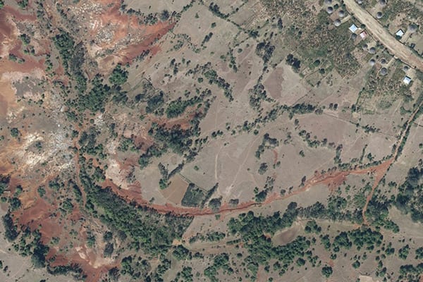
A village in Gurage Zone with different existing land uses – Orthophoto taken in October 2018.
Moreover, the Ethiopian government is keen on establishing land information system database, which potentially fosters information accessibility to users. Likewise, maintaining transparency is one of the core working principles in Ethiopian offices, where land administration is no exception. Nevertheless, the paper-based land data archiving is a bottleneck to transparency where the end users require the goodwill of authorities or experts to get data access. This in turn could be pinpointed as one of the factors for land related corruptions widespread in Ethiopia. Maintaining data transparency requires use of the right tools and methodologies to collect and store data. In this aspect, the LandPKS app is an ideal tool as it will make data openly accessible to all registered users through its data portal.
The issue of sustainable land management has been a priority agenda in Ethiopia. This boils down to the fact that soil erosion is identified as the main environmental degradation causing further socioeconomical instabilities in the country. Soil erosion is aggravated by the recurring drought, over-cultivation, deforestation and overgrazing practices in Ethiopia. To figure out the erodibility risk of a specific area it will be mandatory to: monitor the land cover, understand the soil inherent characteristics, topography and the climate condition. The LandPKS mobile application is developed with a functionality to analyze and correlate the above-mentioned parameters upon which feasible soil conservation decisions could be made. Moreover, from the biophysical soil LandPKS outputs, fertility related variables could be extrapolated which also contributes to the land management decisions.
The LandPKS project is engaged in disseminating the LandPKS mobile app through capacity building training for all kinds of interested stakeholders including government officers, farmers, extension workers, researchers, and students. Often shortage of office computers in Ethiopia is the hurdle in the compilation and analysis of data collected from the field. The LandPKS app will address this issue, as it will enable officers to collect, store, analyse and interpret data all at once using affordable mobile smart phones. This could also assist their daily task of preparing field reports, as LandPKS app gives the option to generate PDF reports, and leaves them with less excuse of not having computers. On top of that, unlike computers requiring broadband or WiFi internet connection to upload data, which currently is a luxury to have in Ethiopian offices, LandPKS data could be uploaded using regular phone internet connection. Not only that, in remote rural Ethiopian villages where there is limited phone signal, LandPKS app users could temporarily save collected data on their portable mobile phone and they should do synchronization to upload data on the web portal whenever and wherever they get internet connection.
Finally, taking into account the indispensable role LandPKS app could play in the land use planning and sustainable land management, LandPKS Ethiopia project pursue opportunities to work in partnership with various implementing stakeholders and mainstream use of LandPKS app into ongoing land management practices. Any organization interested in collaborating with the LandPKS project, and/or receiving a training on the use of the LandPKS app should contact the Ethiopian Country Coordination Officer, Mr. Adane Buni, at [email protected].

Photo 1: Soil samples collected and ready for hand texturing guided by the LandPKS app.
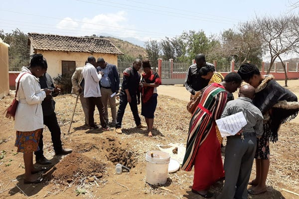
The LandPKS team spent three days last week in Kisarawe District, Tanzania training and testing the new Land Capability Classification (LCC) function of the LandPKS app. The LCC classifies the land into eight classes (from prime agricultural land to land that would be better used for livestock, wildlife conservation, or forestry) based on the potential productivity of the land. The class is determined by slope, soil texture, and seven different soil limitations such as soil depth, permeability, flooding, etc. We were joined in Kisarawe District by staff from Tanzania’s National Land Use Planning Commission (NLUPC) as well as Kisarawe District staff including land use planners, agricultural officers, and livestock specialists.
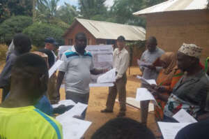
Photo 2: Dr. Charles Mkalawa with the NLUPC leading the LandPKS training with the village government and local farmers.
We spent three days in the Kisarawe District, which is a rural area just outside of Dar es Salaam, the largest city in Tanzania. On the first day, everyone visited the nearby village of Mtamba and the LandPKS team trained the national and district level staff, alongside local village government officials and farmers, on how to use the LCC function within the LandPKS app. We also discussed how the LCC can be integrated into land use planning to better match the land use with the land capability. On the second day, we visited the villages of Masanganya and Marumbo in the Kisarawe District. Dr. Charles Mkalawa from the NLUPC conducted the training with the village governments and farmers on the second day. On the third and last day, we visited Mhaga, and the staff from the NLUPC and Kisarawe District conducted the entire training! It was excellent to see how quickly the staff understood the LCC function and the LandPKS app and were able to train others within three short days. The staff is now well trained to help others learn how to use the LandPKS app for biophysical characterization of the land for land use planning. All of us at the LandPKS team were very impressed and the NLUPC and Kisarawe District staff are looking forward to future collaborations and implementation of the LandPKS app for land use planning efforts in Tanzania and beyond.
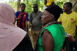
Photo 3: Staff from the Kisarawe District leading the LandPKS training.
The LandPKS app is free to download for both Android and iOS. Learn more about the LandPKS app on the landpotential.org website. Training resources, including guides and online training, are also available on the website. The LandPKS app was developed by the LandPKS Team for the Land-Potential Knowledge System (LandPKs) with support from USAID and USDA-ARS.
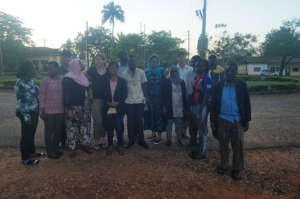
Photo 4: The LandPKS Team, NLUPC Staff, and Kisarawe District Staff as the sun was setting on our third day in Kisarawe.
In Tanzania, the Land Potential Knowledge System has been working with the National Land Use Planning Commission as well as USAID’s Land Tenure Assistance (LTA) Project to assist in effective land use planning and land tenure efforts. LandPKS is a mobile app that helps users identify their soil, and the potential productivity and long term agricultural sustainability of that soil. By identifying areas with sustainable agricultural potential, land-use planners can integrate biophysical assessments into their participatory land-use planning process. The LTA project is helping to revise village-level land-use plans. Once land use planning is complete, LTA is using a mobile technology called MAST (Mobile Application to Secure Tenure) to assist village members to attain a CCRO (Certificate of Customary Right of Occupancy) for their farms and properties. By integrating LandPKS soil information into their land-use plans, LTA and other land-use planners can make better decisions about which areas within a village are suitable for agriculture, and which are not. Focusing agricultural growth on soils suitable for sustainable agriculture not only increases farmer revenues and productivity but saves other village lands for other, less intensive uses such as grazing areas or forest reserves.
At the national level, Dr. Stephen Nindi, Director General of the National Land Use Planning Commission, is working with the LandPKS team to implement LandPKS tools in the future for the national land-use planning process. Tanzania currently uses a 6-step process for participatory land use management, involving community members and stakeholders at every step. On the biophysical side of the land-use planning process, Tanzania draws from the seven land capabilities classes. Categorizing the land into these seven classes helps planners to determine which livelihood activities are sustainable in which areas. For example, land capability class one refers to land that is suitable for all land uses with normal land management practices, such as flat, well-drained, and fertile land. LandPKS could play a key role in helping land-use planners classify land into these seven classes based on soil texture, soil water holding capacity, potential erosion risk, and potential productivity. While soil texture is not the only important soil characteristic, it can be a critical predictor of a land’s potential and its degradation risk. Implementing LandPKS in the land use planning process will simply, and cheaply, help the National Land Use Planning Commission include more biophysical data into their land-use planning process.
Therefore, LandPKS has a role not only in improving sustainable land management for farmers and pastoralists but also on a larger scale through the land use planning process. Matching appropriate land uses to their proper soil types can increase productivity and decrease land degradation, essential goals for long-term environmental sustainability.