In the month of August, our Ethiopia Local Coordinator Adane Buni organized a series of
trainings and pilot tests with the Ministry of Agriculture, Rural Land Administration and Use Directorate.

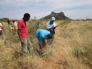
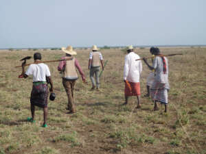
The training series included a Training of Trainers for the Ethiopian Rural Land Administration and Use Experts. The training was hosted by the Ministry of Agriculture and included both classroom presentations and field demonstrations of the app. In total, 227 agricultural officers, researchers and students were trained in using the LandPKS app.
During the pilot testing across several regions of Ethiopia, land biophysical data were collected using the LandPKS app and conventional Ethiopian Rural Land Use Planning methods to compare the approaches as inputs for local level participatory land use planning. The pilot tests showed that the LandPKS and conventional land use planning approaches produced comparable results. It was also determined that the LandPKS mobile app required less expertise and time for data analysis and report preparation. As a result, the Land Administration and Use Directorate has begun planning for the extension of the app out to its land use planning experts. Regional Experts in the Southern Nations, Nationalities, and People’s Region (SNNPR) have already begun training local level rural land use planners to use LandPKS to collect biophysical data for land use planning purposes.
The LandPKS (Land Potential Knowledge System) project is recently launched in Ethiopia to complement ongoing efforts in land administration and sustainable land management. Currently in Ethiopia an emphasis is given on issuing land certificates to secure land tenure rights of rural communities. Although, securing land rights encourages farmers to invest conservation-wise on their land, land demarcation and certification merely based on plot sizes alone could not be sufficient to achieve sustainable land management. Cognizant of this fact, the Ethiopian government is yet to enforce land use policy. The Federal Democratic Republic of Ethiopia Rural Land Administration and Land Use Proclamation No, 456/2005, states:
“A guiding land use Masterplan, which takes into account Soil type, Landform,weather condition, plant cover and socio economic conditions and which is based on a water shed approach, shall be developed…………”
“WHEREAS, it has become necessary to establish an information database. that enables to identify the size, direction and use rights of the different types of landholdings in the country……”
Accordingly, land use policy needs to be backed up with scientific knowledge about the potential of a land. The lack of knowledge about land’s potential is one of the reasons for the underutilisation or overexploitation of lands under occupancy. Thus, making the relevant knowledge readily available is half the solution of the prevailing land misuse problem. Not only that, knowledge of the land’s potential should also be the preceding and the core step while setting up land use policies. LandPKS serves this purpose by availing analysed information about the potential of land following a worldwide accepted standard land evaluation procedures, based on a data gathered by users and retrieved from the cloud by the LandPKS mobile app. The LandPKS app replaces the exhausting, paper based, a qualified expert demanding conventional land evaluation process. The detailed biophysical information about the land supplied by LandPKS will complement the preliminary textual and imagery data which are displayed on the land tenure certificates already being issued to rural land holders in Ethiopia.
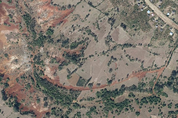
A village in Gurage Zone with different existing land uses – Orthophoto taken in October 2018.
Moreover, the Ethiopian government is keen on establishing land information system database, which potentially fosters information accessibility to users. Likewise, maintaining transparency is one of the core working principles in Ethiopian offices, where land administration is no exception. Nevertheless, the paper-based land data archiving is a bottleneck to transparency where the end users require the goodwill of authorities or experts to get data access. This in turn could be pinpointed as one of the factors for land related corruptions widespread in Ethiopia. Maintaining data transparency requires use of the right tools and methodologies to collect and store data. In this aspect, the LandPKS app is an ideal tool as it will make data openly accessible to all registered users through its data portal.
The issue of sustainable land management has been a priority agenda in Ethiopia. This boils down to the fact that soil erosion is identified as the main environmental degradation causing further socioeconomical instabilities in the country. Soil erosion is aggravated by the recurring drought, over-cultivation, deforestation and overgrazing practices in Ethiopia. To figure out the erodibility risk of a specific area it will be mandatory to: monitor the land cover, understand the soil inherent characteristics, topography and the climate condition. The LandPKS mobile application is developed with a functionality to analyze and correlate the above-mentioned parameters upon which feasible soil conservation decisions could be made. Moreover, from the biophysical soil LandPKS outputs, fertility related variables could be extrapolated which also contributes to the land management decisions.
The LandPKS project is engaged in disseminating the LandPKS mobile app through capacity building training for all kinds of interested stakeholders including government officers, farmers, extension workers, researchers, and students. Often shortage of office computers in Ethiopia is the hurdle in the compilation and analysis of data collected from the field. The LandPKS app will address this issue, as it will enable officers to collect, store, analyse and interpret data all at once using affordable mobile smart phones. This could also assist their daily task of preparing field reports, as LandPKS app gives the option to generate PDF reports, and leaves them with less excuse of not having computers. On top of that, unlike computers requiring broadband or WiFi internet connection to upload data, which currently is a luxury to have in Ethiopian offices, LandPKS data could be uploaded using regular phone internet connection. Not only that, in remote rural Ethiopian villages where there is limited phone signal, LandPKS app users could temporarily save collected data on their portable mobile phone and they should do synchronization to upload data on the web portal whenever and wherever they get internet connection.
Finally, taking into account the indispensable role LandPKS app could play in the land use planning and sustainable land management, LandPKS Ethiopia project pursue opportunities to work in partnership with various implementing stakeholders and mainstream use of LandPKS app into ongoing land management practices. Any organization interested in collaborating with the LandPKS project, and/or receiving a training on the use of the LandPKS app should contact the Ethiopian Country Coordination Officer, Mr. Adane Buni, at [email protected].
Adane Buni is the LandPKS Country Coordination Officer for Ethiopia. Adane has graduated in Water Security and International Development at a Master’s of Science Degree level from University of East Anglia, United Kingdom. Previously he has studied Soil Science(MSc) at Hawassa University, Ethiopia and Soil and Water Engineering and Management (BSc) at Haramaya University, Ethiopia. His thesis work for his Master’s degree in Soil Science focused on the soil acidity problem prevailing across Ethiopia, specifically in the South West Region. Accordingly, he has assessed the effects of different rates of lime addition on improving the properties of an acidic soil in the region. Moreover, his dissertation for his second Master’s degree analysed the Water-Energy-Food nexus in the Upper Nile Basin at national scales.

Adane has approximately nine years of work experience at various organizations in different parts of Ethiopia. He has lectured in the departments of small scale irrigation and rural water supply at Hawassa Polytechnic College for five years. Most of his trainees used to be extension and development workers from Ministries of Agriculture and Water. He was also an Associate Researcher at Ethiopian Institute of Agricultural Research. He was overseeing a research project on the Management of Vertisols, a soil type covering large parts of agricultural lands in Ethiopia known for its inherent water-logging problem limiting its productivity. His specific responsibilities as a researcher were initiating research proposals, analysing field research data and demonstration of research findings to the farmers.
Adane is enthusiastic about the use of tools that assist decision making in natural resource management. He also strongly believes in the importance of digitizing environmental data and making an easy access of information to stakeholders in order to achieve the transformation of Ethiopian Agriculture. That was why he decided to join the LandPKS team and make his own contribution.
Guest post authored by Allison Holt, United States Forest Service
Since 2015, the US Forest Service has been using the Land Potential Knowledge System (LandPKS) to collect monitoring data in Ethiopia to develop a baseline for rangeland conditions and to evaluate the efficacy of rangeland management treatments in an adaptive management approach. As part of the USAID Pastoral Resilient Improved Market Expansion (PRIME) project, US Forest Service (USFS) ecologists Tom DeMeo and Sabine Mellman-Brown have been working with CARE Ethiopia Rangeland Specialists Gudina and Beressa Edessa to track local vegetation changes over time, and to record grazing effects and soil erosion trends. USFS has been conducted monitoring work primarily in the Borana, Guji, and Afar regions of Ethiopia, using both the LandPKS LandInfo and LandCover applications for electronic data collection and online cloud storage. To date, this work has resulted in 149 monitoring plots.