Over the past several months, our LandPKS Tanzania Country Coordinator Elifadhili Daniel has been working hard in partnership with the World Agroforestry Center (ICRAF) to get the word out about LandPKS as a tool for land-use planning and agricultural extension.
For Tanzanian land-use planners, LandPKS has become a valuable decision-making tool. LandPKS is being used by the National Land Use Planning Commission (NLUPC) and the USAID Land Tenure Assistance Project to carry out soil assessments. Since its introduction, the NLUPC has been using the LandPKS Land Capability Classification (LCC) tool to collect soil characteristics data. These data are used to assist in decision making on sustainable land use planning and management in NLUPC project areas. LandPKS has also informed village level land use plans and helped villages formalize land tenure through the Certificate of Customary Right of Occupancy.
Professionals in the agriculture sector in Tanzania have also found how LandPKS can be used as an information resource for agricultural extension. Since October 2018, Daniel has trained over 1,800 individuals including students at agricultural colleges, researchers at the Tanzania Agricultural Research Institute (TARI) and the Agricultural Seed Agency (ASA), nonprofit organizations, and agricultural extension officers in 22 regions across Tanzania. After trainings, agriculture professionals expressed how LandPKS can improve their ability to provide farmers with more accurate recommendations.
Government extension agents from the Manyara region of the Hanang District entering soil texture information in the LandPKS app.
Christian Msipolosi-Songea, a District Agricultural and Irrigation Cooperative Officer in the Ruvuma region noted that “the most intriguing feature about this technology is its ability to provide site-specific information on climate and soil characteristics which will enable us to provide accurate advice to our farmers for decision making on choice of crop varieties, use of inputs like agrochemicals and seed types, and how to [help] cope with challenges of our changing environment’’.
Agriculture professionals also pointed out that an increasing number of families have access to smartphones which opens the possibility for extension agents to teach farmers to use LandPKS. LandPKS is available in Swahili, making it possible for farmers to use the app in their own language. Daniel’s trainings have also prepared extension agents to train other agriculture professionals and farmers to use LandPKS. Thanks to ICRAF and Daniel’s efforts for helping us realize our vision of global access to sustainable land management knowledge.
Various agricultural practitioners including district extension officers, agricultural college trainers, researchers and agricultural seed producers in Morogoro region have expressed their excitement as they were introduced to LandPKS. This was demonstrated after being trained to use the LandPKS mobile app and its application in identifying potential of the land and how it can be used as a decision-making tool for land use planning and management. The training conducted by LandPKS country coordination officer for Tanzania Mr. Elifadhili Daniel from 10th-20th Dec. 2018 in Morogoro whereby agricultural professionals from Chalinze District, Morogoro District Council, Mvomero District Council, WOPATA, agricultural researchers from Tanzania Agricultural Research Institutes – Cholima Dakawa and Ilonga centres, Ministry of Agriculture Training Institute trainers and field extension officers from Agricultural Seed Agency( ASA) were reached. A total of 111 professionals were trained at this phase and were able to use LandPKS application.
The training was organized as part of LandPKS developers’ efforts to roll out the technology to agricultural practitioners in Tanzania and capacitate them to; characterize local site conditions (soil, topography, climate) using LandPKS mobile app, analyze and interpret outputs in specific contexts and to use LandPKS for collecting information that will facilitate decision making for sustainable land use planning.
To facilitate quick understanding, the training was divided into two phases, the theoretical part whereby the participants were oriented to the LandPKS application and assisted to download and troubleshoot. The second part encompassed a field practical training where the participants were involved in soil texturing and data collection using the LandPKS app. This was the most exciting part of the training where they appreciated site-specific instant results by LandPKS.
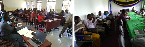
(Left) Indoor session with Morogoro Municipal extensionists. (Right) Indoor session with TARI Ilonga researchers
Applicability of LandPKS
Agricultural professionals reached out during the training described how LandPKS would be a great help in their day to day activities. ASA seed experts were pleased with the advent and introduction of this technology by acknowledging that it just came at the right time. ”We have a larger field exceeding 3000 acres. LandPKS tool will help characterize our soils at various parts of our field and guide us in planning and we will start this exercise tomorrow, however we may need more training and practice to perfect it’’. Similar comments were made by one of the principal TARI researchers at Ilonga Station during the wrap up session, who commended efforts made by LandPKS developers to bring easy to use technology for soil characterization and ultimately land use planning, emphasizing on more training and guidance from the country coordination officer.
On the other hand, LandPKS also gave tremendous zest to District agricultural extension officers reached, who expressed their eagerness to learn more about the app and train their colleagues who did not attend the training. One could notice the interest on their faces as they were actively involved in digging and working the soils and follow the guide to determine the textural class.

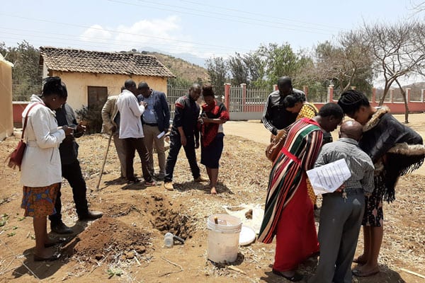
Researchers digging a pit at the ASA farm, Morogoro, Tanzania
Both indoor and outdoor training sessions were very interactive where a number of questions pertaining the app, interpretation of the results and the use of LandPKS website resources were asked and answered and comments given which were subsequently communicated to LandPKS developers.
Featured image: Soil texturing (WOPATA) extension worker